3D laser scanner enables forward-looking research
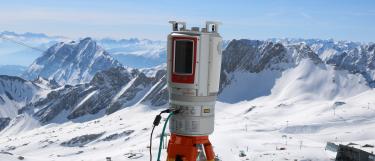
The Top Researchers Fund enabled the University to acquire a terrestrial 3D laser scanner of the latest generation for Professor Bernhard Höfle. Using this new scanner, the GIScience and 3D Geospatial Data Processing Department of Professor Höfle is able to not only develop cutting-edge Earth observation but it also helps the researchers to establish a new field of research in geography – “Autonomous Earth observation”. With its broad range of up to 4 km, its millimetre precision as well as its ability to take up to 1.2 million measurements per second, the laser scanner is perfect for terrain campaigns.
The research in Heidelberg focuses on the effects of climate change (e.g. melting of glaciers, changes regarding permaforst and coasts), natural hazards (e.g. landslides, floods) and applications in agriculture and forestry.
Thanks to the 3D laser scanner, we will be able to test our new computer-based methods of autonomous Earth observation in the terrain and to further develop our methodology, in the years to come.
Prof. Dr Bernhard Höfle, GIScience and 3D Geospatial Data Processing, Institute of Geography


