A Route Planner for Every Eventuality
In geoinformatics, researchers analyse geodata and develop user services
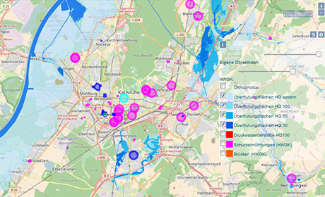
When a devastating earthquake struck Nepal in the spring of 2015, the geoinformatics scientists at Heidelberg University leapt into action: The researchers and students set up an emergency route planner on the Internet, just as they had five years before after the earthquake in Haiti. Disaster workers were able to use the planner to identify roads that were still passable and determine the fastest route to the affected areas. They also obtained data on key points of contact such as hospitals, rescue centres and emergency camps. This humanitarian support through the development of disaster mapping technologies is just one example of the hands-on projects of the geoinformatics scientists at the Institute of Geography at Heidelberg University. Their work is based on geographical data from a variety of sources that the scientists analyse from a variety of aspects.
"We study geodata, that is, digital information that can be assigned to a specific spatial position on the Earth's surface," explains Prof. Dr. Alexander Zipf, Director of the Geoinformatics Department. "This data is then recorded in the social web or by volunteers, such as in the OpenStreetMap project, the free world map often referred to as the Wikipedia of cartography. We analyse the data's quality and potential for use and develop new methods for these analyses." So that the knowledge and technology from basic research in geoinformatics can find its way into practical use more easily, the Heidelberg Institute for Geoinformation Technology (HeiGIT) was founded at the Institute of Geography in 2016 with financial support from the Klaus Tschira Foundation.
Work is focused on implementing practical projects and services in three areas in particular: big spatial data analytics, intelligent location-based services, and navigation, such as disaster mapping for humanitarian aid as in the case of the emergency route planner. "Nowadays large volumes of all kinds of data are collected automatically by technical sensors or generated by users on social media or through crowdsourcing," explains Alexander Zipf. "We help prepare the data for practical use in spatial applications. To this end, we develop methods to specifically extract usable geodata from heterogeneous data streams."
Geoinformatics at Heidelberg thus represents an interface between technology and its application. In the field of intelligent navigation, the researchers develop globally available services for creating customised mobility profiles aligned with special requirements and various scenarios. "Whereas logistics companies are always looking for ways to optimise their routes, outdoor sportspeople are in search of routes that meet their individual needs," states Zipf. For disaster mapping for humanitarian aid, the scientists collaborate with users to develop innovative processes and services to better exploit the potential of different data sources.
In one project funded by the European Union, the Heidelberg geoinformatics scientists are focused on pedestrians with limited mobility – such as individuals in wheelchairs or with baby carriages who rely on barrier-free pathways, and count stairs, steep inclines and poor street surfaces among their greatest obstacles. As part of the CAP4Access research project, the scientists are developing a specific profile to supplement the existing, freely accessible route planner profiles for cars, lorries, pedestrians and cyclists. In addition to route planning, the service also shows reachability zones – areas that can be reached from a given starting point within a certain period of time. The goal of the CAP4Access project is using new technologies to draw attention to existing barriers in European cities. For optimal results, the scientists need as many people as possible to enter their knowledge on route conditions into OpenStreetMap, hence the many volunteers from the Internet community involved in collecting and processing the data. Crowdsourcing is also a field of research in Heidelberg, with geoinformatics scientists working on methods for crowdsourcing of 3D geodata.